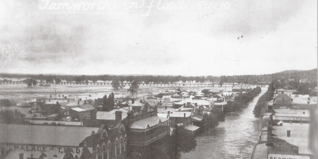
The relatively minor flood experienced in Tamworth back in late March this year was “a drop in the ocean” compared to some of those experienced here in previous years, with the one pictured from 1910 being one of our worst. The first significant local flood experienced here by Europeans was in 1840, with some of the other major inundations occurring in 1864, 1955, 1984 and 2000. This photo, taken from the Post Office clocktower in Peel Street, looking north-west towards the Viaduct, clearly shows the flood coverage in the CBD. At its peak the water depth at the Peel/Bourke Street corner was measured at 2.7m. Perhaps residents then regretted that Surveyor-General Sir Thomas Mitchell’s original 1849 Tamworth Town Plan hadn’t been fully embraced, where he designated the elevated Marius Street as our main street.
The flood brought to an end our 3rd Showground on today’s No.1 Oval/Bicentennial Park, relocating to West Tamworth. The flood was precipitated by nearly 300mm of rain falling over 6 days in January 1910, bringing down both the Cockburn and Peel River floodwaters. The wall of water divided itself down both Peel Street and Lower Street (now Kable Avenue). Many people were left stranded on rooftops. Logs swept downstream proved to be a destructive and dangerous hazard. It was estimated the local damage caused by the 1910 flood was the equivalent of over $15 million in present day values. The subsequent building of the East Tamworth levee bank in the 1930’s, and the more recent West Tamworth levy banks, has offered much more flood protection to our town, as has to a certain extent been the increased capacity of Chaffey Dam.
Mike Cashman. Tamworth Historical Society